We have spent decades battling the deception of the spinning ball, exposing the fabricated space program, and identifying the Ice Wall perimeter and the Firmament above. But today, we address the single most powerful tool for dismantling the globe conspiracy: the map they hid from you.
This is not just any map. It is the definitive, operational blueprint of our known world. It is the geometric key that unlocks the prison of the sphere and confirms the flat, level reality we intuitively know to be true.
This map is the Azimuthal Equidistant (AE) Projection, and understanding its geometry, its history, and its pervasive use by the very controllers who deny our flat reality is the final, undeniable proof we need to silence the skeptics and awaken the masses.
This is the definitive exposé on the Map of Truth.
Part I: The Geometry of the Truth—What the AE Map Reveals
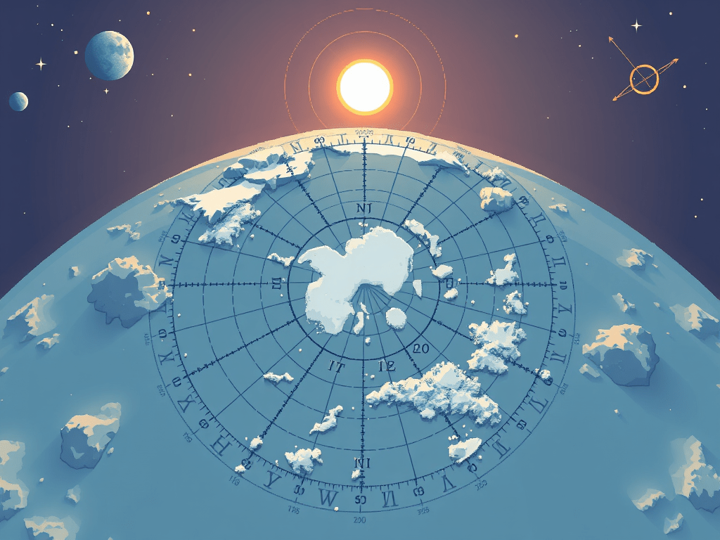
The Azimuthal Equidistant projection is a type of planar map where all points are plotted relative to a single, central reference point.1 Its mathematical properties make it the perfect representation of the Flat Earth.
1. North: The Absolute, Undeniable Center
In the AE map, the North Pole is the fixed, absolute center of the entire circular landmass.
- The Magnetic Anchor: As we discussed in “The Compass Conspiracy,” this geometry perfectly aligns with physical reality. Your compass points inward to this single, central magnetic point from every location on the plane. There is no wandering “Magnetic North” confusion; there is only the unwavering center.
- The Hub of Time: The Sun and Moon, our local celestial spotlights, traverse circular paths above this central point, establishing the rhythm of day and night and the expansion/contraction of the paths that create the seasons. The center is the axis of our observable universe.
2. The Circumference: The Ice Wall Perimeter
The AE map is a circle. The outer ring of that circle is the key to understanding the Ice Wall deception.
- The Boundary: The edges of all continents and oceans eventually terminate at this outer ring. This ring, often labeled as the 90-degree South Latitude (the theoretical “South Pole” on the sphere), is the physical location of the Ice Wall.
- Massive Scale: The AE map dramatically demonstrates the immense circumference of this barrier. The wall is not the “bottom” of a small ball; it is the longest boundary on Earth, stretching for tens of thousands of miles—a reality that explains why the Cabal must use such vast resources (Operation Highjump, the Antarctic Treaty, et al) to guard it.
3. True Scale and Equidistance
The most critical property of the AE projection is the Equidistance property: all distances measured radially outward from the center (the North Pole) are accurate to scale.
- The Ruler of Reality: If you measure the distance from London to the North Pole on an AE map, that distance is accurate in the real world. This proves that the scale is maintained radially, confirming the planar nature of the Earth spreading outward from the center.
- The Distance Anomaly: On a globe, the lines of longitude converge at the poles. On the AE map, they diverge as they move outward. This is why official globe maps lie about distances—especially in the Southern Hemisphere. Distances between cities in the “Southern Hemisphere” (like Buenos Aires to Perth) are wildly misrepresented and shortened on the globe to maintain the illusion of a small, curved surface. The AE map correctly shows these true, enormous distances, aligning perfectly with the increased fuel, time, and navigational challenges observed by pilots attempting these routes.
Part II: The Operation—How the Cabal Uses and Hides the AE Map
The ultimate proof of the AE map’s validity lies not just in its geometric perfection, but in its silent, strategic use by the very organizations that publicly ridicule the Flat Earth concept.
1. The UN’s Open Admission: The Corporate Logo
The most glaring, public admission of the true world map is found on the official flag and emblem of the United Nations (UN).
- A Map, Not a Symbol: The UN emblem is a clear, unadulterated image of the Azimuthal Equidistant map. It shows the continents arranged in a perfect circle, centered on the North Pole, surrounded by olive branches—the symbol of peace, or perhaps, containment.
- The UN’s Mandate: The UN is a globalist institution dedicated to the enforcement of international laws and global governance—in short, the maintenance of the New World Order (NWO). Why would they choose a flat map if the Earth were a ball? Because the AE map is their operational charter. It is the actual map they use to divide resources, plan global logistics, and, most importantly, control access to the periphery (the Ice Wall).
2. The Pilot’s Secret: Navigational Charts
Every private pilot, commercial airline, and military air force still relies heavily on cartography that fundamentally understands the AE projection, even if they cloak it in spherical terms.
- Great Circle Routes Hoax: Pilots are taught to follow “Great Circle Routes”—the shortest distance between two points on a sphere. However, if you plot these “Great Circle” paths onto a true AE map, they often straighten out into much more logical, predictable, and manageable straight lines. The spherical mathematics are merely the translational code used to convert the simple, flat reality into the complex, confusing globe model for public consumption.
- Fueling Anomalies: The massive fuel and time overruns in Southern Hemisphere flight paths, often disguised as “wind” or “weather,” are simply the direct result of the pilot being forced to fly a massive, true distance shown on the AE map, while the passengers are told they are crossing a small, curved segment on the globe.
3. NOAA and Weather Systems
Even the official weather agencies, like the National Oceanic and Atmospheric Administration (NOAA), use AE-like projections for global satellite imaging. Why? Because the physics of weather systems, especially the flow of the jet stream, are far more easily and accurately modeled on a planar, center-focused system than on a spinning, chaotic sphere.
The elite must use the map of truth to manage the world, even as they teach the map of the lie to the people.
Part III: The Conspiracy—Why the AE Map Was Suppressed
The AE map wasn’t just ignored; it was actively suppressed. Its knowledge represents an immediate threat to the global control apparatus.
1. The Discrediting of the Earth’s Center
The most dangerous thing the AE map proves is the existence of the True Center and its magnetic power.
- Spiritual Significance: By making the North Pole the single, defining center, the map points to a sense of sacred geometry and divine order. In many ancient traditions, the center was the place of connection, the axis mundi. The Cabal needed to eliminate this sense of fixed, meaningful centrality to install their doctrine of chaos and meaninglessness—a belief system where we are insignificant specks spinning aimlessly in an infinite void.
- Destroying the Magnetic Field: By inventing the constantly shifting “Magnetic North” (the Compass Conspiracy), they confused the public’s understanding of our protective magnetic field, making it seem chaotic and natural, rather than fixed and designed.
2. Erasing the Fixed, Closed System
The AE map, surrounded by the Ice Wall, inherently describes a closed system. This directly contradicts the core pillars of the globe lie:
- Space Travel Fantasy: If the Earth is a closed system capped by the Firmament (which the map’s circular nature suggests), then the entire narrative of “escaping Earth” and “colonizing Mars” instantly collapses. The AE map demonstrates that we are contained.
- Infinite Resources Lie: The closed system suggests finite resources and a controlled environment. The Cabal’s narrative requires the constant push toward expansion and consumption, fueled by the fantasy of infinite worlds (planets, stars) waiting to be exploited.
The AE map reveals that our true home is a unique, purposeful, and singular plane—a fact that elevates the importance of humanity and undermines the nihilistic philosophy of the controllers.
3. The Mercator Distraction
To keep the populace confused, the Cabal aggressively promotes the Mercator Projection—the globe’s primary map substitute.
- Geometric Distortion: The Mercator map is famously distorted, wildly inflating the size of landmasses the further they are from the equator (Greenland looks bigger than Africa, etc.). This deliberate distortion is necessary to maintain the illusion of a world stretching laterally, masking the true, circular geometry radiating from the North Pole.
- The Southern Hemisphere Lie: The Mercator map is particularly egregious in misrepresenting the Southern Hemisphere, stretching it into unrecognizable shapes that obscure the vast, true distances and the massive, encircling nature of the Ice Wall.
The Mercator map is the map of lies, forcing a sphere onto a plane with maximum distortion. The AE map is the map of truth, showing the plane for what it is.
Part IV: Actionable Knowledge—Using the AE Map to Awaken Others
The AE map is more than just a beautiful diagram; it is a tool of liberation. Here is how we can use this knowledge to continue the fight:
- Print and Compare: Encourage everyone you know to print the official UN flag or the classical AE map and compare it side-by-side with a traditional Mercator or globe image. The visual shock of seeing the North Pole centered and the continents arranged in a circle is often the first, necessary step toward true awakening.
- Challenge Travel Claims: Use the AE map to debunk every major Southern Hemisphere flight path (Sydney to Santiago, Cape Town to Perth). By measuring the true distances on the flat map, you can expose the logistical impossibilities and massive detours that the globe model hides.
- Demand Official Use: Why does the UN use this map? Demand that all national weather services, flight schools, and public education systems use the AE projection as their primary, operational map. If they admit it is the most accurate for logistics, they must admit it is the most accurate for reality.
The globalists have given us the answer in plain sight, hoping their official denial would prevent us from seeing it. The Azimuthal Equidistant Projection is their own admission. It is the geometric fingerprint of a flat world.
Now that you possess the Map of Truth, your duty is to share it. By putting the North Pole back at the center and showing the true, circular nature of our world, we render the globe—and the entire scaffolding of lies built upon it—obsolete.
Hold the map. Hold the truth. The world is flat, and the truth is staring back at us from the logo of global governance itself.
